Over the past decade, land surveying in the UAE has evolved rapidly. Previously, most topographic surveys were carried out by small field teams using total stations, with results delivered mainly as drawings and coordinate reports. As construction activity across Dubai increased, the demand for faster and more precise survey data grew significantly.
Today, developers, contractors, and engineering consultants expect high-accuracy survey information delivered quickly, often within tight project schedules. Technologies such as 3D laser scanning, UAV drone mapping, LiDAR surveys, and BIM-ready digital models are now widely used to capture and process site data more efficiently.
For surveying companies operating in Dubai’s fast-paced construction sector, adopting these modern tools is essential. Teams that combine advanced equipment with efficient digital workflows can complete surveys faster, reduce repeat site visits, and deliver reliable data that supports better planning and construction decisions. If your project requires accurate surveying, 3D scanning, or LiDAR mapping in Dubai or across the UAE, partnering with an experienced survey team helps ensure dependable results.
Below are five key technology trends that are transforming the way land surveying is carried out across Dubai and the wider UAE.
1. AI-Powered Drone Surveying
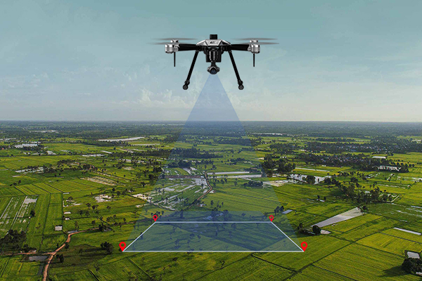
Drone surveying has evolved far beyond simple aerial photography. In many construction and infrastructure projects across Dubai and the UAE, unmanned aerial vehicles (UAVs) are now used as primary data-capture tools.
Modern survey drones combine AI processing, LiDAR sensors, and thermal imaging, allowing survey teams to collect accurate spatial data in a fraction of the time required by traditional field methods.
AI-Based Data Processing
New drone systems can process data using machine-learning algorithms that automatically identify features on the ground.
These systems can detect stockpiles, structures, terrain variations, and construction changes directly from aerial scans. This reduces the need for manual interpretation and speeds up the production of survey models.
Aerial LiDAR Mapping
Drone-mounted LiDAR sensors are capable of capturing millions of laser points per second. These points form a highly detailed 3D point cloud, which can be used to create accurate terrain models and digital site replicas.
This technology is especially useful for:
-
- Large development sites
-
- Infrastructure corridors
-
- Earthworks monitoring
-
- Urban mapping projects
The resulting data can be integrated directly into Building Information Modeling (BIM) environments used by architects and engineers.
Thermal Inspection Capabilities
Many advanced drones also include thermal cameras that detect temperature differences in structures or underground utilities.
This allows survey teams to identify potential pipeline leaks, insulation problems, or structural heat variations without invasive inspections.
2. 3D Laser Scanning and LiDAR Mapping

One of the major advances in modern surveying is the use of 3D laser scanning. Instead of measuring individual points one at a time, a laser scanner captures millions of measurements within seconds, creating a detailed point cloud that represents the exact shape of a structure or landscape.
For complex construction sites in Dubai – such as high-rise buildings, industrial facilities, or infrastructure projects – this level of detail helps surveyors capture accurate site conditions that traditional surveying methods can often miss.
How 3D Laser Scanning Works
Laser scanning isn’t just about “capturing data” – it’s about getting the ground truth the first time so you don’t pay for it later. In the UAE’s fast-paced construction market, a 5mm error in an as-built drawing can lead to weeks of delays.
-
- Millimeter-Perfect Digital Twins: The scanners pulse light millions of times per second to build a high-fidelity Point Cloud. This helps capture every beam, pipe, and slab exactly where they sit in the real world.
-
- BIM & CAD Integration: This data drops straight into Revit or AutoCAD, allowing your team to run clash detections and structural checks in the office, not on the site.
-
- Zero “Return Trips”: Since we capture the entire environment in one go, any measurement that is needed – now or even months later from now – is already in the file. No more sending crews back to the site for more measurements.
LiDAR for Large-Scale Mapping
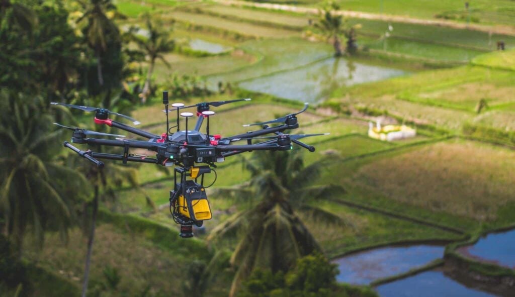
When we need to map massive areas, we put away the static scanner and bring in LiDAR. Whether we’re mounting sensors on a drone for a desert topo or a vehicle for an RTA corridor, we’re collecting kilometers of survey-grade data in a single shift.
Why our clients are switching to LiDAR in this era:
-
- RTA & Etihad Rail Corridors: High-accuracy as-builts can be delivered at highway speeds. It’s the only way to get data without putting a ground crew in the line of fire or shutting down traffic.
-
- Large-Scale Topo: We take 100+ hectare sites from “raw land” to a fully gridded BIM model in days, not weeks.
-
- Utility & Pipeline Planning: We map complex routes across rough, inaccessible terrain without needing to mobilize a massive ground team.
-
- Coastal & Environmental: We track sand movement and erosion along the Gulf shoreline with millimeter-level precision to keep development projects on track.
For major infrastructure here in the UAE, LiDAR isn’t just “faster” – it’s the only way to get the data you need without stalling your project or the city’s traffic.
3. Advanced GNSS Surveying Systems
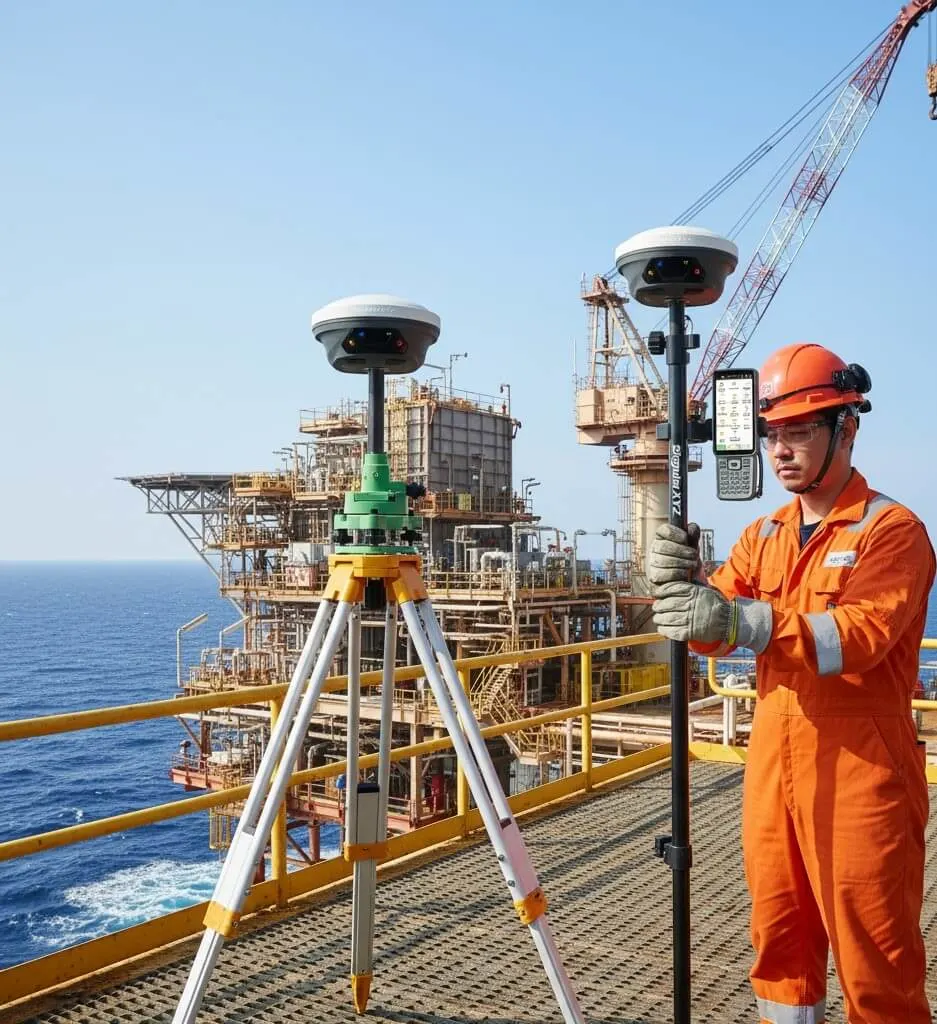
Global Navigation Satellite Systems (GNSS) have become essential tools for modern surveying operations.
Current GNSS receivers can process signals from multiple satellite constellations including GPS, GLONASS, Galileo, BeiDou, QZSS,NavIC,etc. By combining signals from these systems, surveyors can achieve centimeter-level positioning accuracy under most site conditions.
Key Advantages of Modern GNSS Equipment
GNSS technology improves survey productivity by removing the need for direct line-of-sight measurements between points.
This makes it particularly effective for:
-
- Establishing site control networks
-
- Setting out building grids and road alignments
-
- Conducting large topographic surveys
-
- Verifying land boundaries
-
- Monitoring structural movement or settlement
With modern RTK and network correction services available across the UAE, GNSS has become a core component of many surveying workflows.
4. IoT Integration in Survey Equipment
The days of manual data transfers is now almost obsolete. Nowadays the survey gear is fully IoT-enabled, creating a direct, real-time link between the field and the office. This isn’t just “integrating technology”; this is cutting out the downtime that usually kills project momentum.
How the “Always-Connected” workflow keeps the project moving:
-
- Live Data Sync: As soon as a point is shot, it’s live in the office. No more waiting for a crew to return to base to download raw files—your design team can verify the as-built data while the crew is still on the stake.
-
- Remote Health Checks: If a sensor starts throwing errors, we can diagnose the instrument remotely, often pushing firmware updates or calibration checks without the gear ever leaving the site.
-
- Smart Asset Tracking: We track every piece of kit across multiple sites in real-time. If a unit is due for its mandatory calibration or service, we know about it before it becomes a liability on your project.
-
- Instant Stakeholder Transparency: We give your project managers direct access to the latest point cloud or grid, so they’re making decisions based on this morning’s reality, not last week’s report.
In the fast-paced UAE market, data is only as good as its speed. If the survey team isn’t connected to the cloud, then they are working with older and maybe unreliable data.
5. Digital Survey Data for BIM and Smart Construction
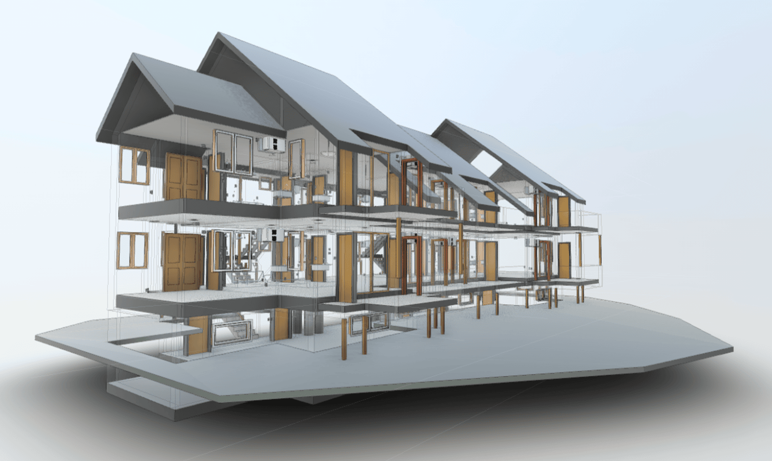
Having moved past the era where a simple set of 2D CAD drawings was enough to break ground. In the UAE today, if the survey data doesn’t integrate directly into a BIM model, then the project is already behind. Relying on static coordinate lists has stopped; instead, “digital site truth” is provided – high-fidelity models that map your design intent directly to the as-built reality on the ground.
Why this is the new standard:
-
- Clash Detection: We identify structural interference—like a utility pipe running through a column—while it’s still just a point on a screen, not a concrete-poured disaster on-site.
-
- Progress Tracking: We map your earthworks and structural progress against your original design files, giving your project managers a “percentage-complete” view based on reality, not optimism.
-
- Engineering Coordination: When the structural, MEP, and architectural teams all pull from our high-accuracy digital models, you eliminate the “design drift” that typically plagues multi-contractor sites.
-
- Minimized On-Site Hacks: By delivering survey-grade data that matches the design intent, we reduce the need for last-minute cutting, welding, or site-based modifications that kill your profit margins.
For the fast-paced development cycles in Dubai and the UAE, this isn’t just about “innovation.” It’s about building smarter, faster, and holding your contractors accountable to the as-built reality.
Conclusion
The surveying industry in the UAE is evolving rapidly as construction projects demand faster, more accurate, and more detailed site data.
Technologies such as AI-powered drone surveys, 3D laser scanning, LiDAR mapping, advanced GNSS systems, and connected IoT equipment are transforming how surveyors collect and deliver information.
Companies that invest in these tools are better positioned to support complex construction and infrastructure projects across Dubai and the wider UAE.
As the industry continues to move toward digital construction and smart infrastructure, modern surveying technology will remain a key foundation for accurate planning and successful project delivery.
Information prepared by:
Benson A.
Technical & Service Manager with 22+ years of experience in the Industry
Dated: 11-03-2026