
Sokkia built the iM-60 Series model for crews, surveyors, and engineers who just need to get out there, shoot their points, and complete the project. The big selling point here is how it plays with your phone. Instead of dealing with clunky onboard menus, you connect the gun to the CoordyNavi app on your smartphone. From there, you can pull up your design files, fix your points right on the spot, and knock out your stakeouts way faster than the older routines. Unlike older manual total stations that require tedious manual data entry, the iM-60 series integrates directly with the CoordyNavi smartphone app. By pairing the hardware with your mobile device, you can sync design files, calculate points on the fly, and execute stakeouts significantly faster than traditional paper-and-panel methods.
The SOKKIA iM-50 series vs the iM-60 series
The Sokkia iM-50 and the iM-60, look almost identical. Both are solid, entry-level manual total stations, and both actually have built-in Bluetooth, with the same exact distance and angle accuracy out of both models.
The real difference is how they handle the data out in the field.
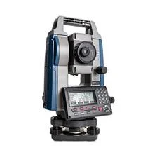
The iM-50 is a reliable workhorse, but typically run in the old-way: either punching in points on the onboard screen or linking it via Bluetooth to a standard data collector running software like Magnet Field.

The iM-60, on the other hand, is built for modern, mobile-first workflows. Sokkia optimized it specifically to talk to the CoordyNavi smartphone app right out of the box. Instead of spending extra on a dedicated, ruggedized field controller just for basic layouts, the crew can just use their phones. The design files can be over Bluetooth, calculate your stakeouts on the go, and see your layout progress straight on the app screen.
Software & Workflow
iM-50 Series: Onboard SDRbasic (The Classic Setup): This is the standard, basic layout option. Operating out of the box like a traditional total station, it relies on the physical instrument screen for basic shots. For anything beyond simple point collection, it will be meaning to be stuck doing manual data input or carrying a separate, dedicated field controller.
MAGNET Field Integration (The Digital Upgrade): To increase the capabilities over SDRbasic, you need to connect the instrument to a dedicated field data collector running MAGNET Field software.
Key Advantages of the MAGNET Field Workflow, includes bypassing Clunky Onboard Controls, Direct CAD Importation and Advanced Roading & COGO
iM-60 Series: Carrying three different pieces of gear across a site just to verify a couple of shots, is tedious. Instead of using old data collectors and paper plans, the Sokkia iM-60 manual total station completely changes the daily setup by letting to run the entire layout right from a smartphone.
Software & Workflow
By linking the unit over Bluetooth to the CoordyNavi mobile app – which runs on whatever Android or iPhone available – get a full, real-time visual map on the screen. It literally points right to the next stakeout mark, so that the user won’t be stuck guessing or staring at a dated onboard menu.
Key advantages of the CoordyNavi includes turning the smartphone into a primary data collector with mobile data integration, Real-Time Visual Guidance and Flawless syncing via Bluetooth within seconds. This gives the user Unified Field Data and Instant Digital Deliverables.
Battery & Field Time
iM-50 Series: Known for very long battery life, running for up to 28 hours on a single charge.
iM-60 Series: Optimized for continuous smartphone tethering, running for approximately 14 hours on a single charge.
Key Features of the iM-60 series
- High‑speed (0.9s), high‑precision (2 +2ppm) reflectorless measurement (0.3 to 500 m).
- Japan‑quality durability with IP66 protection and −20°C to +60°C operation.
- Graphic LCD, 50,000‑point memory, USB support, and 14‑hour battery.
- In addition, on‑board applications, the iM‑60 now comes standard with Bluetooth, enabling smooth connectivity and operation with handheld applications.
- IP66 rating
Minimum Smartphone Requirements

Core features and capabilities
- Visual Map-Based Navigation: Chasing for points on a tiny, low-resolution total station screen is a massive time consumption. Shifting that data over to a modern smartphone interface completely changes how you work on site. Instead of guessing the way across the site, just pull up the map on the screen and walk. The software uses bright, real-time color tracking to draw a direct line straight to your target. If it is way off line, the screen flags it instantly. As stepping closer to the mark, the display shifts colors giving the rodman an immediate, idiot-proof visual cue to the exact second the prism lands.
- No Expert Knowledge Needed: Finding experienced instrument operators right now is next to impossible. The absolute last thing needed on a busy job site is a green helper completely spoiling a layout just because they got confused by a legacy, text-heavy data collector. This app cuts out that exact headache. Instead of making the crew memorize endless button patterns or legacy menus, it gives them a straightforward, visual routine. If they know how to use Google Maps on their phone, they can run this software. It walks them through the stakeout point-by-point, letting your newer field hands layout lines and grab tight shots on their very first day.
- CAD and Cloud Compatibility: This system runs on a high-performance, unified CAD engine that opens and renders DWG and DXF files instantly, exactly the way the engineers drew them. Once the shots are loaded, with built-in cloud connectivity and instant data sharing, field crews can send shot data straight to the office the second it’s stored. Project managers can monitor the crew’s progress in real time, catch discrepancies early, and push out updated design files to the field instantly.
DWG (Drawing): For civil engineering and survey crews, DWG is the non-negotiable standard. Because it is Autodesk’s native, compressed binary format for AutoCAD, it packs complex 3D meshes, dynamic blocks, and detailed layer states into a tiny footprint. Unlike heavy open-text alternatives, it won’t crash the field hardware or corrupt the coordinate systems during handoffs. The advantages of DWG are that it hasZero Lag, Flawless Data Hand-offs and Rock-Solid Layer Locking.
DXF (Drawing Exchange Format): When exporting layouts to non-Autodesk platforms or sending cut profiles to a shop floor, DXF is the industry standard. It acts as an open-source bridge, allowing different vector applications to share design data without proprietary software barriers. By saving geometry as plain ASCII text instead of compressed binary code, DXF lets fabrication hardware – like CNC routers, plasma tables, and laser cutters – read tool paths directly without translation errors. This text structure causes DXF file sizes to increase to 3-10 times larger than a native DWG. If the drawing is not cleaned up before exporting, these massive files will lag field tablets and stall older machine controllers during a load.
Conclusion & Final Verdict
Survey and civil engineering crews using standard data collectors and physical keypads generally look for field reliability over mobile app connectivity. The Sokkia iM-50 manual total station fits this exact workflow, dropping smartphone integration to focus entirely on long-term power management and hardware stability. The biggest operational advantage of the iM-50 is its 28-hour continuous battery run-time. This extended capacity keeps the instrument running on remote jobsites where grid power or charging stations are completely unavailable. Rather than connecting to a phone app, the unit uses onboard Bluetooth to sync directly with ruggedized field tablets running MAGNET Field software.
If the civil engineering or survey crew wants to strip out unnecessary project overhead, the Sokkia iM-60 manual total station represents a major shift toward modern, mobile-first field workflows. By replacing expensive, proprietary data collectors with the free CoordyNavi smartphone app, this instrument turns any standard Android or iOS device into a real-time visual map interface. The immediate trade-off is a lower 14-hour battery run-time caused by continuous Bluetooth tethering, but the operational payback on a busy construction site is massive:
- Instant Crew Onboarding: The Google Maps-style visual tracking lets green field hands stake out lines accurately on day one without memorizing legacy menu layouts.
- Flawless Office-to-Field Sync: A unified CAD engine opens native DWG and DXF files right on your phone screen, letting draftsmen push over-the-air design adjustments straight to the instrument.
- Reduced Gear Costs: You eliminate the need to buy and maintain separate, thousands-of-dollars field tablets just to pull off routine layout tasks.
The Final Verdict: While the two total stations share identical internal EDM specs – delivering down-to-the-millimeter distance measurements and the same angular accuracy options – they operate on completely different data management platforms out in the field.
As for the iM-50 series, survey teams that already own a fleet of ruggedized data controllers running heavy software like MAGNET Field. A massive 28-hour continuous battery life. This extended power management makes the iM-50 the superior option for remote, off-grid infrastructure layouts, highway expansions, or long pipeline runs where daily charging is impossible.
The iM-60 series on the other hand the iM-60 is a modern, smartphone-driven layout tool designed to strip out unnecessary field hardware expenses. It is a modern, smartphone-driven layout tool designed to strip out unnecessary field hardware expenses. It is for construction contractors and civil engineering firms fighting crew shortages who need a fast, intuitive system that lowers the technical barrier for new hires. The Standout Advantage is the Direct, out-of-the-box integration with the CoordyNavi smartphone app. By running the layout over Bluetooth via an iOS or Android device, you eliminate the need to purchase dedicated, costly field tablets.
While internal measuring tolerances are identical, power management styles differ significantly due to their data-sharing demands:
| Technical & Operational Metric | Sokkia iM-50 Workflow | Sokkia iM-60 Workflow |
| Reflectorless Range | 0.3m to 500m | 0.3m to 500m |
| Distance Measurement Speed | Fine: 0.9 seconds | Fine: 0.9 seconds |
| Environmental Protection | IP66 Certified (-20°C to 60°C) | IP66 Certified (20°C to 60°C) |
| Continuous Battery Life | Up to 28 Hours | Approx. 14 Hours (Due to Bluetooth tethering) |
| Primary Controller Type | Dedicated Field Tablet (e.g., MAGNET Field) | Standard Smartphone (CoordyNavi App) |
| Internal Memory Capacity | 50,000 Points / USB Export | Unlimited Cloud Sync / Smartphone Storage |
Information updated by:
Dubai,U.A.E.
Technical & Service manager with 25+ years in the industry