
GeoSpatialNext Middle East is the premier media and event platform driving spatial intelligence across the region. We track the high-impact convergence of AI, reality capture, and digital twins, hosting elite regional conferences that connect municipal authorities and geomatics pioneers to advance national-scale infrastructure workflows.
Place and Dates: September 8–9, 2026 | Dubai.
Industry Overview
The Middle East geospatial sector is undergoing an unprecedented boom, transforming from a supporting technical discipline into the core infrastructure pillar for the region’s historic giga-projects. Fueled by aggressive national digital mandates – most notably Saudi Vision 2030 and the Dubai 2040 Urban Master Plan – regional development now mandates high-fidelity spatial intelligence. Engineering firms and municipal agencies are rapidly deploying automated LiDAR workflows, GIS networks, and cloud-native digital twins to meet strict state-backed construction timelines and manage smart city assets in real time.
Market Growth: The UAE’s geospatial sector is experiencing an unprecedented surge, serving as the primary commercial engine for broader spatial intelligence investments across the entire MENA region.
Digital Twins & BIM: The integration of BIM and GIS is now the operational standard for Middle Eastern infrastructure, anchored by the Dubai Digital Twin platform to map hundreds of thousands of municipal buildings in real time. Engineering firms use these unified pipelines to automate feature extraction and run predictive smart city simulations.
GeoAI: Spatial AI – the native integration of computer vision, deep learning, and geographic data—is reshaping how automated systems interpret physical environments in real time. By processing complex spatial arrays instantly, this tech allows autonomous vehicle networks, logistics fleets, and urban transport systems to deploy predictive mobility routing, react to real-world edge cases, and eliminate transit latency across high-density corridors.
Key Focus Areas
GeospatialNext and regional forums heavily emphasize several key technical pillars:
- Digital Twin & Smart Infrastructure: Deploy high-fidelity 3D digital twins to automate real-time urban planning, optimize utility resource management, and secure carbon-neutral municipal sustainability.
- GeoAI & Earth Observation: Deploy advanced AI-driven spatial analytics to automate real-time climate monitoring, streamline supply chain logistics, and maximize regional asset efficiency
- Reality Capture: Unlock actionable geospatial insights by turning physical environments into precise, high-value digital assets with our advanced LiDAR, mobile mapping, and drone imagery solutions
The Middle East is no longer just adopting geospatial technology – mega-projects like Saudi Vision 2030 and UAE Centennial 2071 are actively cementing the region as the global epicenter for spatial innovation in urban planning, national security, and resource management. Partner with our leading geospatial experts today to leverage world-class mapping solutions for your next enterprise development.
Delegates:
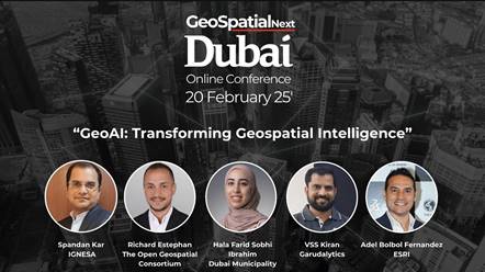
Here is a deep dive into the core pillars, real-world applications, and market drivers behind Geospatial Next in the Middle East.
1. From Maps to Living Replicas: Digital Twins & BIM-GIS Integration
Traditional mapping captures a static past, but Geospatial Next delivers living digital twins of entire nations. By blending Geographic Information Systems (GIS), Building Information Modeling (BIM), and IoT sensors, we are pioneering self-aware cognitive cities that optimize infrastructure in real time.
2. The GeoAI Revolution & Earth Observation
Middle Eastern leaders are leveraging GeoAI—the powerhouse fusion of AI and spatial data—to trade reactive tracking for predictive, automated governance that resolves infrastructure bottlenecks before they even form.
- Automated Urban Change Detection: Municipalities are ditching slow manual field audits for automated code enforcement by pairing high-resolution satellite imagery with computer vision. By cross-referencing weekly satellite passes directly against official cadastral registries, this satellite property monitoring system instantly flags zoning violations and unauthorized construction without ever deploying an inspector.
- Predictive Policing and Public Safety: By layering historical incident data with real-time variables like public events, weather, and transit delays, the Dubai Police and regional security forces use predictive spatial analytics to deploy patrols before incidents even occur. These advanced GeoAI models map crime and traffic accident hotspots in real time, moving public safety from reactive policing to predictive urban security.
- Environmental Resilience: To combat rapid desertification and severe water scarcity, regional agricultural teams are deploying GeoAI to monitor groundwater depletion and automate precision drip-irrigation networks in real time. By layering spatial climate data with machine learning, this framework protects vulnerable farming zones and optimizes every drop of water before resource depletion threatens crop yields.
3. National Space Programs & Local Data Sovereignty
Middle Eastern powers are securing absolute data sovereignty by launching native satellite constellations rather than relying on Western or Asian hardware, marking a massive shift for regional Geospatial Next initiatives. This localized space tech ensures total control over national spatial data pipelines, protecting security and delivering hyper-accurate intelligence built specifically for regional terrain.
- The UAE Space Program: The UAE’s deployment of MBZ-SAT—the region’s most advanced high-resolution imaging satellite—instantly equips local entities with rapid, hyper-precise earth observation data. Sourcing this intelligence natively allows regional developers and defense agencies to bypass third-party providers completely, ensuring ironclad data security for sensitive national infrastructure projects.

- Saudi Space Agency Initiatives: Saudi Arabia is aggressively scaling its downstream space applications by training a massive local workforce to process spatial data natively rather than outsourcing to foreign firms. This heavy investment in localized geospatial talent keeps strategic environmental insights and sensitive national security data securely within the Kingdom’s borders, ensuring absolute data sovereignty.

4. Economic Impact and Market Drivers
The hard financial and operational metrics behind this spatial shift explain why regional leaders view Geospatial Next as a non-negotiable economic pillar rather than just a tech upgrade. By slashing infrastructure overhead and automating public workflows, spatial intelligence directly accelerates GDP growth across the GCC.
- PwC Middle East Insights: Integrating GeoAI into the region’s utility, infrastructure, and energy sectors acts as a massive economic multiplier, streamlining supply chains and optimizing national resource allocation. Industry data shows that this advanced spatial intelligence slashes capital project delays by up to 20%, saving regional developers billions in operational overhead.
- The Smart Valuation Push: Sovereign wealth funds like Saudi Arabia’s PIF and the UAE’s ADIA, alongside leading real estate developers, leverage advanced spatial analytics to dictate multi-billion-dollar land valuations and pinpoint proximity to planned transit hubs. By integrating satellite verification directly into their due diligence pipelines, these funds run ironclad, auditable ESG compliance checks that satisfy global institutional investment standards.
5. Overcoming Regional Hurdles
To resolve critical infrastructure bottlenecks and data fragmentation, public-private partnerships across the GCC are rapidly uniting to tackle the Middle East’s unique geospatial integration challenges.
- Data Interoperability: Integrating legacy governmental data silos into a unified national spatial data infrastructure (NSDI) remains a complex hurdle. Countries are resolving this by mandating unified open-data standards across all ministries.
- The Talent Gap: The sophistication of GeoAI requires professionals skilled in both geography and advanced data science. To bridge this, local universities (such as Khalifa University and King Abdullah University of Science and Technology) are partnering with global spatial giants like Esri and Hexagon to build dedicated geospatial research hubs.
Conclusion
Driven by mandates like Saudi Vision 2030, the Middle East is now the global epicenter for spatial innovation, leveraging GeoAI and cognitive digital twins to slash infrastructure delays by 20%. By integrating hyper-precise BIM-GIS networks and native satellite data, regional giga-projects are completely redefining smart city asset valuation and resource resilience. Don’t let your enterprise fall behind the curve—maximize your infrastructure workflows by joining elite geomatics pioneers and municipal authorities at GeospatialNext this September 8–9, 2026, in Dubai to partner with our leading spatial intelligence experts today.
Event described by:
Benson A. (25+ years in the Geospatial Industry)