
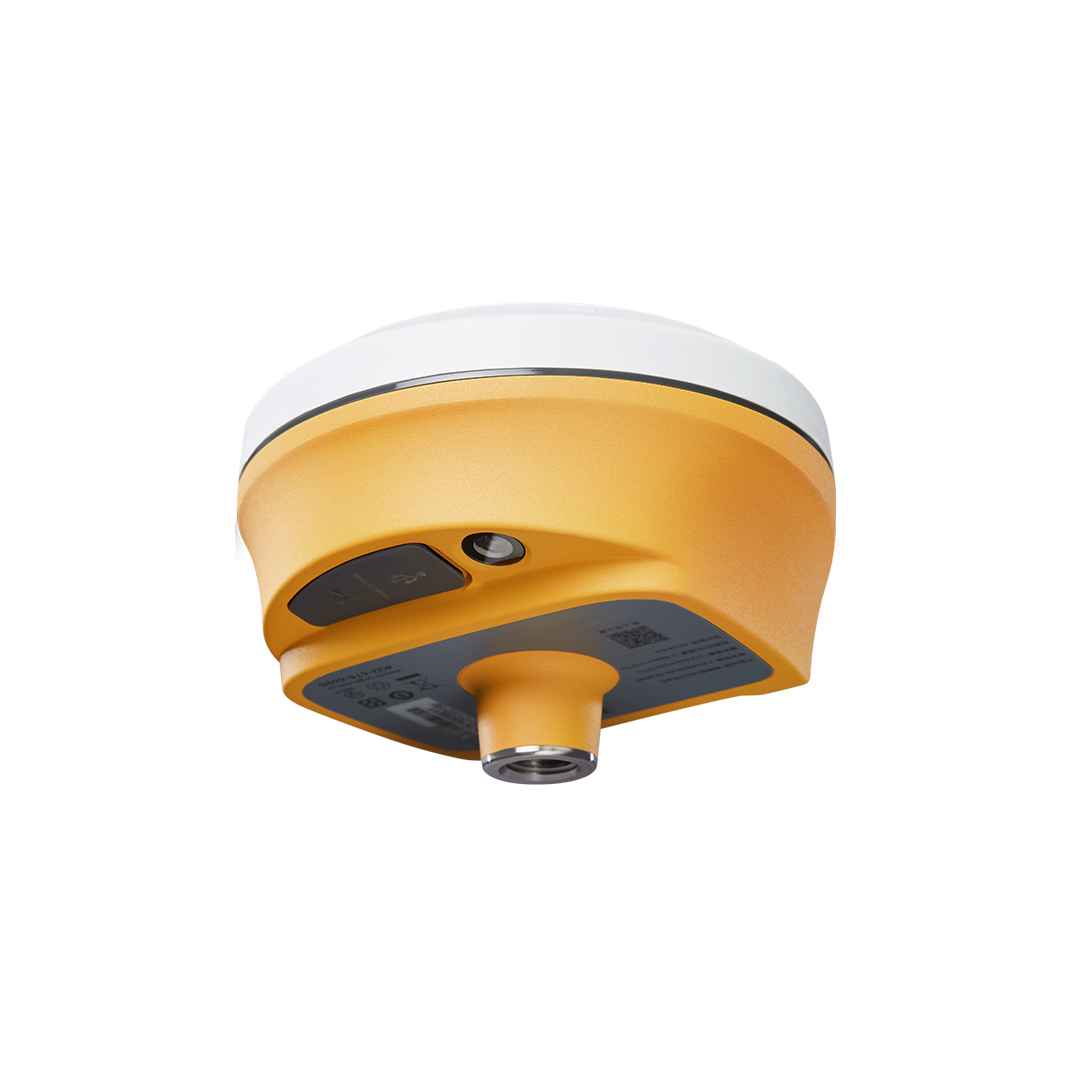

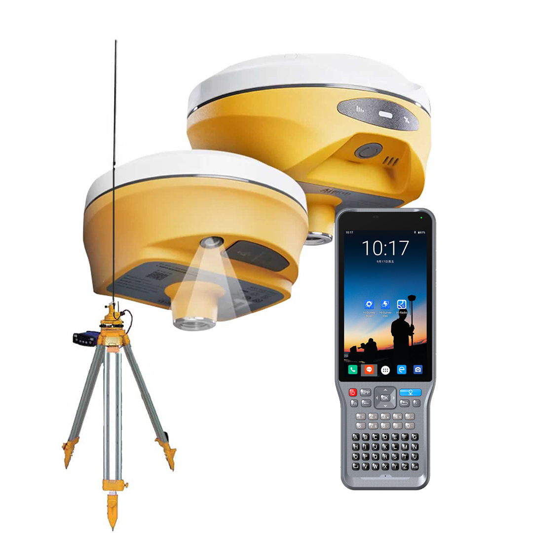

Hi-Target V500 GNSS RTK SYSTEM
The Hi-Target V500 GNSS RTK System is a robust and advanced solution for professionals who require high-precision positioning in demanding environments. Featuring cutting-edge technology, the V500 is designed to deliver accurate, reliable data for applications such as surveying, construction, and mapping. With its versatile design and powerful performance, the V500 is an excellent choice for professionals seeking efficiency and precision in the field.
Key Features:
Advanced GNSS Technology for Superior Accuracy
The Hi-Target V500 is equipped with advanced GNSS technology, supporting multiple satellite constellations, including GPS, GLONASS, Galileo, and BeiDou. This multi-constellation support enhances positioning accuracy and ensures reliable performance even in challenging environments, such as urban canyons or dense foliage. The V500 is built to deliver precise results, making it suitable for tasks that demand high levels of accuracy.
Compact and Durable Design
The V500 features a compact and lightweight design that makes it easy to transport and handle in the field. Despite its small size, the V500 is rugged and durable, with an IP67 rating for dust and water resistance. This ensures that the receiver can withstand harsh environmental conditions, including exposure to dust, water, and extreme temperatures. The V500 is designed for long-lasting performance, providing reliable operation in challenging work environments.
High-Performance RTK Positioning
The V500 supports Real-Time Kinematic (RTK) positioning, enabling centimeter-level accuracy in real-time. This high-performance RTK capability makes the V500 ideal for precision surveying, construction layout, and other applications that require accurate real-time data. The V500’s RTK performance ensures that users can achieve precise results quickly and efficiently, reducing the need for post-processing and enhancing productivity in the field.
Versatile Connectivity and Communication
The V500 is equipped with a range of connectivity options, including Bluetooth®, Wi-Fi, and USB interfaces, allowing for easy integration with data collectors, controllers, and other devices. This versatile connectivity ensures that the V500 can be easily adapted to various workflows and field setups, providing flexibility for different applications. The receiver also supports UHF radio communication for long-range data transmission, further enhancing its versatility in the field.
User-Friendly Interface and Operation
The Hi-Target V500 is designed with user convenience in mind, featuring an intuitive interface that simplifies operation. The receiver’s built-in display provides real-time status updates, allowing users to monitor the device’s performance and positioning data at a glance. The V500 is also compatible with Hi-Target’s field software, enabling seamless data collection and management in the field.
Extended Battery Life for Long Field Sessions
The V500 is powered by a high-capacity battery that provides extended operating time, ensuring that you can work for long hours without interruptions. The receiver’s efficient power management system optimizes battery usage, allowing for longer field sessions and reducing the need for frequent recharging.
Accessories for Hi-Target V500 GNSS Receiver
The Hi-Target V500 comes with a range of accessories that enhance its functionality and usability in the field. These accessories are designed to ensure that the V500 operates efficiently and reliably in various applications.
Standard Accessories:
High-Capacity Battery: Provides extended operating time for long field sessions.
Battery Charger: Quick and efficient charger for recharging the V500’s battery.
Carrying Case: Rugged carrying case for safe transport and storage of the V500.
Mounting Bracket: For secure attachment of the V500 to survey poles or other equipment.
Antenna: High-performance antenna for enhanced signal reception and positioning accuracy.
Optional Accessories:
External Radio Module: For extended communication range in remote areas.
Data Collectors: Handheld devices for advanced field data management and control.
Tripods and Mounting Poles: Stable mounting solutions for precise setup in the field.
External Power Supplies: Additional battery packs and power solutions for extended field sessions.
Applications of Hi-Target V500 GNSS Receiver
The Hi-Target V500 GNSS receiver is a versatile tool that can be used in a wide range of professional applications, from construction and land surveying to environmental studies and precision agriculture.
1. Land Surveying and Boundary Mapping:
The V500 provides high-precision GNSS data for land surveyors, ensuring accurate boundary mapping, topographic surveys, and land subdivisions. Its RTK positioning capabilities allow for real-time data collection with centimeter-level accuracy.
2. Construction Layout and Engineering:
The V500 is ideal for construction projects that require precise layout and staking. Its compact design and high-performance RTK positioning make it easy to set out foundations, road alignments, and infrastructure layouts with confidence.
3. Environmental and Agricultural Surveys:
The V500 can be used for environmental monitoring, agricultural planning, and land-use surveys, providing accurate data for decision-making in these fields. Its versatility and durability make it a valuable tool for professionals working in remote and challenging environments.
4. Utility and Infrastructure Development:
Engineers and utility planners can rely on the V500 for accurate data collection in utility installations, road construction, and other infrastructure development projects. Its rugged design ensures reliable performance in urban and rural settings alike.
5. Geodetic and Monitoring Surveys:
The V500 is suitable for geodetic surveys that require high accuracy over large areas. It is also ideal for monitoring deformation, structural health, and land movement over time, providing reliable data for long-term studies.
The Hi-Target V500 GNSS Receiver is a powerful and versatile instrument that delivers high precision, durability, and ease of use for professionals across various industries. With its comprehensive accessories and advanced features, the V500 ensures that you can complete your surveying and mapping tasks with accuracy and efficiency.


Reviews
There are no reviews yet.