
CHCNAV P330 PRO VTOL Drone
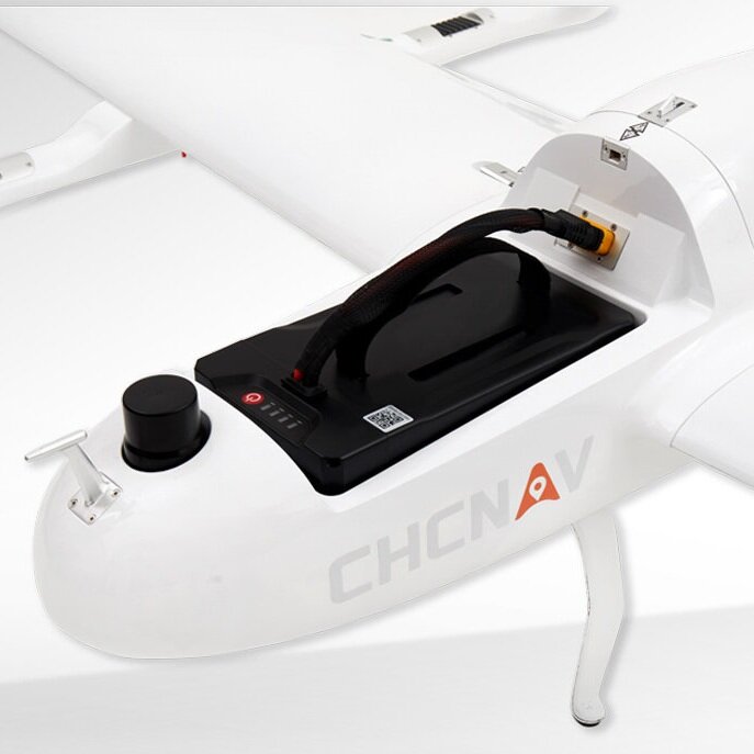
The CHCNAV P330 Pro VTOL (Vertical Takeoff and Landing) drone is a cutting-edge unmanned aircraft system (UAS) designed for high-efficiency aerial surveying and mapping applications. With an ultra-efficient aerodynamic design, this drone offers long endurance, covering vast areas of up to 20 km² in a single flight. It integrates advanced aviation technologies such as dual GNSS systems, triple IMU systems, and high-accuracy GNSS RTK/PPK modules, ensuring reliable and precise mapping results without the need for ground control points (GCPs). The P330 Pro is also equipped with a swappable sensor bay, allowing users to quickly switch between various payloads, including orthophoto cameras, oblique cameras, multispectral cameras, and lightweight laser scanners, making it versatile for different aerial survey tasks.
Key Features:
High Efficiency and Long Endurance:
- The P330 Pro drone boasts an ultra-efficient aerodynamic design, enabling it to achieve 150 minutes of flight time with its payload. This endurance allows the drone to cover large areas of up to 20 km² per flight, making it ideal for large-scale mapping projects, such as highway corridors and open-pit mine surveys.
Trusted by Aerial Survey Specialists:
- The P330 Pro is equipped with state-of-the-art aviation technologies, including a triple-redundant flight control system, dual GNSS system, triple IMU system, and dual antenna positioning and orientation. These features, combined with 5 safe return-to-base strategies and 9 safety monitoring checks, ensure safe and reliable flight operations, making the drone a trusted tool for aerial survey professionals. Its design guarantees high-altitude performance and can operate at altitudes of up to 6,000 meters.
Cost and Time Efficiency:
- With an integrated high-accuracy GNSS RTK/PPK module and advanced photogrammetry software, the P330 Pro delivers centimeter-level mapping accuracy without requiring systematic ground control points (GCPs). This reduces the time and cost of data acquisition by eliminating the need for extensive field crews, thereby increasing the return on investment for aerial survey missions.
Swappable Airborne Sensors:
- The P330 Pro’s modular design allows for quick and easy swapping of airborne sensors in the field. It supports a wide range of sensors, including orthophoto cameras for 2D mapping, oblique cameras for 3D modeling, medium-frame cameras, multispectral cameras, and lightweight laser scanners. This versatility enables the P330 Pro to adapt to various mapping and topographic survey requirements.
User-Friendly Software:
- The drone comes with EasyFly ground control software, making mission planning and pre-flight checks straightforward and efficient.
The P330 Pro VTOL drone is a high-performance unmanned aircraft system (UAS) specifically engineered for aerial surveying and mapping applications. Its combination of high accuracy, long endurance, and multiple payload options make it an indispensable tool for mapping and surveying professionals. The P330 Pro’s ability to conduct small- and large-scale aerial surveys with exceptional data quality and significant cost and time savings positions it as a viable alternative to manned aircraft for various applications, including surveying and mapping, mining, construction and infrastructure, environmental monitoring, and agriculture.
The P330 Pro’s versatility, reliability, and efficiency make it a top choice for professionals seeking a robust solution for aerial survey and mapping projects. Whether for detailed topographic surveys, large-scale infrastructure mapping, or precision agriculture, the P330 Pro delivers the performance and accuracy required to meet the most demanding aerial survey needs.


Reviews
There are no reviews yet.