
The Future : Mapping
The flat 2D blueprints are almost obsolete. Across the MENA region, multi-billion-dollar mandates like Saudi Arabia’s Vision 2030 and the UAE’s Dubai 2040 Urban Master Plan are fueling a massive, data-driven construction boom. Regional developers are no longer building from static images; they are engineering responsive, net-zero environments using live GIS mapping and predictive digital twins that optimize resources spontaneously. This isn’t just a tech upgrade—it is a complete overhaul of how modern cities operate. To see how these live data streams are reshaping regional asset management and how your business can capitalize on the shift,
With the region’s mega-projects expanding at breakneck speed, the MENA Geospatial & Space Technology Forum 2026 is easily the most important event on the calendar this year. Running from June 24–25 right here in Dubai, it’s the one place where the aerospace, GIS, and urban planning sectors actually collide. Think of it as a massive think-tank where international tech disruptors and local policymakers sit down to map out the next decade of smart infrastructure. If your business relies on spatial data or regional growth, you genuinely need to be at the venue. At the event, they are breaking down the biggest trends, market shifts, and tech breakthroughs that will actually matter at this year’s forum.
1. The Regional Market Surge: By the Numbers
Geospatial data isn’t just a tool for mapping out construction sites anymore. Moving into 2026, it has evolved into a critical piece of infrastructure driving major business and government decisions across the entire MENA region. If you look at where the capital is actually moving, the regional market trajectory reveals three massive investment shifts that are fundamentally reshaping the industry.
The Global Momentum: Globally, geospatial analytics is tracking toward a $157 billion market value by 2029, riding a steady 9.6% CAGR (Compound Annual Growth Rate). We’re seeing that exact momentum flood the MENA region right now. Location intelligence isn’t a lower priority tech anymore – roughly 74% of corporate data buyers have pulled spatial analytics directly into their daily workflows to manage shifting infrastructure demands. If you want to see exactly how regional players are adjusting their data budgets to keep up with this pace,
- The UAE Landscape: The UAE is seeing some serious momentum in the geospatial space right now, with the market tracking toward a $440 million valuation by 2029 on a steady 7.76% CAGR. Honestly, a massive part of what’s driving those numbers is the region’s flat-out obsession with smart cities. It’s no longer just a buzzword—municipal planning teams out here genuinely need real-time mapping data just to keep basic, daily city infrastructure running the way it’s supposed to.
- The Saudi Arabian Boom: Driven by Vision 2030 giga-projects like NEOM, AlUla, and the Red Sea Project moving from blueprints to reality, Saudi Arabia’s geospatial market is on a fast track, projected to surge from $370 million to nearly $600 million by 2029 at a steady 9.22% CAGR. Managing the daily operations, logistics, and sustainable growth of these flagship smart cities requires next-generation infrastructure. Consequently, a robust National Spatial Data Infrastructure (NSDI) has shifted from a tech luxury to an absolute necessity for the Kingdom.


2. Ground to Galaxy: The Tech Pillars of 2026
Modern engineering no longer stops at the ground level. To build truly smart, resilient cities, there must be a continuous, real-time link between orbital sensors and terrestrial positioning tools. This critical intersection is the core focus of the upcoming forum, “Exploring New Frontiers: Driving Geospatial and Space Innovation for Smart and Resilient Cities.” The bottom line: A resilient city cannot be built using isolated data. The future of infrastructure relies entirely on a seamless pipeline connecting space-borne telemetry straight to ground-level accuracy.
Space Infrastructure & Earth Observation (EO)
Etihad-SAT finally gives the Gulf region true autonomy in space by solving a persistent problem for local teams: dependency on clear weather. By using advanced Synthetic Aperture Radar (SAR) rather than traditional optical sensors, the satellite captures high-resolution imagery through thick cloud cover and total darkness. For surveyors, engineers, and defense analysts across the GCC, this creates a constant, reliable data stream for monitoring urban sprawl, tracking environmental changes, and securing critical infrastructure.
GeoAI and Predictive Analytics
Traditional GIS gives you a snapshot of your assets, but GeoAI actually lets you look ahead. Instead of just logging an asset’s current condition and waiting for something to break, we are now using machine learning to spot patterns and forecast structural degradation, environmental risks, and logistical bottlenecks before they cause a shutdown. Moving from reactive maintenance to proactive asset management is the easiest way to cut down operational risk on live infrastructure projects.
Live Digital Twins and BIM Integration
For years, BIM and GIS have operated in completely separate silos—one mapping the interior design of a building, the other handling the geographic world outside it. Today, true asset lifecycle management requires merging these two environments into live, interactive Digital Twins. By bridging this gap, engineers and project managers can feed real-time field data straight into active operational models, turning static design files into highly responsive, smart systems.
3. Real-World Applications and Regional Drivers
The geospatial and smart city technologies highlighted at this forum aren’t theoretical concepts—they are the active digital frameworks underpinning the MENA region’s most ambitious giga-projects right now. For surveyors, civil engineers, and project managers across the GCC, integrating next-generation positioning, high-precision coordinate geometry, and remote sensing workflows is a baseline requirement to prevent costly field errors and operational delays. To scale modern smart cities on schedule, the industry must transition from isolated data silos to live, integrated geospatial pipelines that ensure absolute precision on live construction sites.
Climate Resilience: Dubai’s Deep-Tunnel Drainage Project
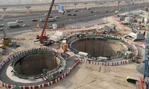
Following the recent record-breaking storms across the UAE, building climate resilience is now an immediate engineering priority, as seen in Dubai’s multi-billion-dollar Deep-Tunnel Drainage Project. By leveraging advanced GIS simulations, engineering teams are running complex hydrological models to pinpoint structural vulnerabilities and map out the exact rapid response measures needed to flood-proof our urban infrastructure.

Mass Mobility: The Dubai Metro Blue Line
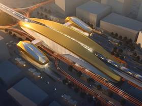
The construction of the 30-kilometer Dubai Metro Blue Line and its 14 new stations rely entirely on high-precision spatial engineering. Right now, project teams are using advanced GIS modeling to finalize corridor planning, optimize route alignments, and balance local land-use density. By integrating this spatial data early, the project ensures seamless multi-modal transit connectivity that aligns perfectly with the Dubai 2040 Urban Master Plan.
Unified Transit: Abu Dhabi’s GeoTRANS / DARB
Abu Dhabi’s Department of Transportation has brought together its separate transit datasets into a single, unified enterprise GIS network using ArcGIS and Geocortex architectures. This system serves internal teams through GeoTRANS and provides public access via the DARB portal, keeping all cross-agency data sharing strictly aligned with the Abu Dhabi Spatial Data Infrastructure (AD-SDI) framework.


4. Operational Excellence in Extreme Environments
For the engineers, surveyors, and technical service teams working on the ground, the forum highlights a critical reality: your field data is only as reliable as the calibration of your sensors. Whether you are running high-precision total stations, GNSS receivers, or advanced LiDAR scanners, even the most sophisticated spatial software can’t fix errors caused by uncalibrated hardware.
The Path Forward
To conclude and in short, the MENA Geospatial & Space Technology Forum 2026 is bringing together the top voices in the industry, with key representatives from the UAE Space Agency, the Bahrain Space Agency, and major regional developers all in one room. As space-based radar, predictive GeoAI analytics, and high-precision field hardware continue to merge, this event is going to give us a direct look at how real-time spatial data is actively shaping the next generation of regional infrastructure.
Data Furnished by:
Benson A. (Technical Manager – 25 years in the Geospatial Industry)