Mobile Mapping System for Land Surveying
h2Mobile Mapping Systemh2pMobile mapping equipment is extremely helpful in land surveying applications for collecting accurate geospatial data and generating detailed 3D panoramas of any given location. If you are looking to buy mobile mapping systems such as Side Scan Sonars from trusted brands like HI Target, you are at the right place with Rise Geo Control Systems. Aside from delivering products from known and trusted brands at highly competitive prices, our customers can avail free delivery to any location within the UAE. Please browse through our product catalogue to find mobile mapping systems in line with your requirements. To know more about the product themselves or any purchase-related assistance, feel free to send us an inquiry today!p pMobile mapping systems such as side-scan sonars are important pieces of equipment in surveying applications. Widely used in a number of industries such as surveying, construction, agriculture, and forestry, these systems help the surveying team map land features such as buildings and other structures like roads and vegetation accurately. They are primarily used to collect data about where things are located and generate maps accordinglyp
The Leica Pegasus TRK utilizes artificial intelligence capabilities to transform mobile mapping. Pegasus TRK leverages AI in various workflow areas.
The Leica Pegasus TRK utilizes artificial intelligence capabilities to transform mobile mapping. Pegasus TRK leverages AI in various workflow areas.
The Leica Pegasus TRK utilizes artificial intelligence capabilities to transform mobile mapping.
The Leica Pegasus TRK500 Neo is a single scanner performing 500,000 measurements per second and generating a single line point cloud pattern. Pegasus TRK was designed from scratch and took into consideration the single sensor characteristics to make them work at their best.
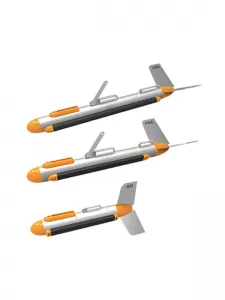
1.switch freely between CW and CHIRP
2.multiple frequencies
3. 100kHz, 400kHz or 900kHz
4. clearer view of the water bottom
5.dual simultaneous
6.versatile high-resolution
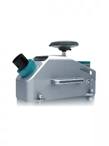
Fully integrated, compact design, simple mount High-density, high accuracy point cloud with 360° geo-referenced images Users calibration-free, vehicle independent